2018 Fall Run - Official Topic

Ask for Rick (Manager) , no one else .. I already told him that's why I was taking the pic to see if you guys were interested ..
 
We had over 40 last year.
We could easily surpass that with
good weather and turn out from St John
Mustang crowd.
 
"Leave Saint Andrews via 127 toward Saint Stephen .
A couple options
Local question How is the road up the 127 to the 760 Elmsville / Johnson Settlement back to Saint George ?"

Did this full route today , was a nice trip , I just detoured into Calais to pick up my stepper motors.. The above #127 is in great shape but the covered bridge is out on #760 so there is a detour through Reardon Rd and stillwater Rds with a good stretch of dirt road ..not sure how long this will be out , I will check again this summer if it's any thing like my local Hammond River covered bridge, it was out for a couple years and then set up an ugly steel modular bridge ...
 
Timing of all this is very important.
Not sure of routes and times.
Gerry has done this several times and
We have on many occasions discussed
How it needs to work.
But an idea is simple.
Leave at 9am Sharp.
With stop for coffee around 10- 10:30
Lunch around 12 to 1.
Small break in afternoon.
Nice photo opp spot is good.
All stops have to included restroom break.
Each stop will be 30-40 minutes, lunch
1 to 1.5 hours. With ideal time back will be handy 5
With anything over 30 cars it will take 8-9 hours to
Cover 3-4 hours of normally driving.
More cars more time.
Last run we had 42 cars,
If weather is good and get decent turn out
From St. John and southern NB Mustang folks
We could top that.
 
Ok. Dirt road is a bad sign.
How about we leave Saint Andrews head up the 127 to Lawrence station, pick up the #3 and come back near St Stephen - then continue on the TCH to St George - to Pennfield ??
 
Could also possibly take the #770 through rollingdam to st George.. The 2nd falls and the bonny river have some nice views if it's not too long of a detour
 
With the covered bridge out at Saint Patrick on the NB760 as a result of the flooding I’m suggesting we leave Saint Andrews on the 127 , through Bayside an on to the TCH#1 back to Pennfield . This will shorten the drive time by 1/2 hour but allow for photo time in both Blacks Harbour / Beaver Harbour loop and on the Dipper Harbour / Chance Harbour loop and still get us back to the Saint John area by 5-5:30 so supper is not too late. Open for thoughts
 
Ok Folks revisions to look at let me know what you think

I've had some local input as to locations to stop for bathroom breaks / refreshments and some possible picture locations.

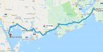
I'm starting \the run from McAllister drive- not sure yet where the hotels will be so no doubt this will update as time gets closer

Head west on Route 1 , Take exit 86 and head down RT 175 Through Lepreau, to the Hagerty Cove Road and on to the New River Provincial Park. We will arrive here in about 40 minutes. I see the parking lot is gravel but looks in good shape. I don't know if the park is open in September but might make a good first bathroom stop / picture location if open. I expect we will be here 15-25 minutes if it works that the park is open. Looks like a good place for a drone shot (Hint-Hint)
Back on the 175 and continue through Sealy's Cove loop and to Pennfield Ridge

As if now planning route 785 to Lake Utopia and then route 780 brings us back to Saint George Tim Hortons - for about 10:45AM
Parking has been determined to be OK - I expect this stop will take 30 minutes minimum.
Leave Saint George via Main Street , then on to 760 Back on TCH1 at exit 45 then TCH exit 39 and we take route 127 in to Saint Andrews.
We should arrive 11;45 - 12 noon
Its only 1:45 drive time , 130 kms but with a couple of stops 3 hours will be gone.

I expect we will be in Saint Andrews a couple of hours - not sure where the restaurant will be but with pictures at the park suggested by Mineral Gray and a meal it will be 2 pm-2:15 leaving Saint Andrews

Here is the proposed route to Saint Andrews

6-13-2018 9-35-41 PM.jpg

I'm very open to make adjustments - tried this route - gives us more coastal - each way

Let me know what we need to change
 

Attachments

  • Start6-13-2018 9-52-06 PM.jpg
    Start6-13-2018 9-52-06 PM.jpg
    87.1 KB · Views: 0
Back
Top